
The Monashee Almanac is an online journal that shares history, mysteries and stories about early British Columbia and in particular the Monashee, Okanagan and Shuswap.
Celebrating History, Mysteries & Stories
A Mystery Unfolds:
Ancient World
Monashee
of the
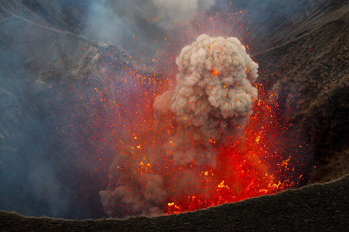
The southcentral interior of British Columbia is rich in natural history, in particular the Okanagan Valley as it links north to the interior plateau and east to the Monashee Mountain range. In this region the most recent geological events begin to unfold beginning with a torrent of molten lava caused by eons of volcanic activity.
Along the eastern edge of the Okanagan are the Monashee foothills which have within them part of a volcanic field made up of numerous, small, basaltic volcanoes. Individual volcanoes have been active for at least the last 3 million years during which time the region was covered by thick glacial ice at least twice.
An Almanac Legend
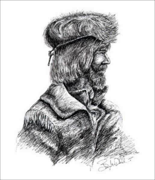
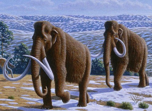
David Thompson: Mammoth Hunter
His men were startled to see a set of large tracks in the snow. Each footprint measured 14" long by 8" wide...
Volcanic eruptions underneath and through the thick blankets of glacial ice produced numerous unique glacial volcanoes and deposits, which may have occurred during the initial formation of both the Camels Hump and Bluenose Mountain.
These sub glacier volcanic eruptions and surface eruptions between the periods of glaciations, filled river valleys with many layers of basaltic lava flows and deposited the tertiary series of rocks that we find today.
It’s unknown just how active lava flows had become 20,000 years ago but today we can find evidence of this spectacular activity that goes back millions of years.
The Camels Hump, Bluenose and Saddle Mountain display ancient basaltic flows. Basaltic lava shrinks as it cools and forms vertical columns such as those found near Dennison Lake south of Creighton Valley. Rows of rock like those found on Layercake Mountain above Gallagher’s Canyon in Kelowna can peal off the cliff face like slices of bread, preserving the vertical nature of the cliff. The lava would most certainly cool as ice became the next resident that would begin to sculpt the landscape off and on for sixty thousand years.
The Last Ice Age
Throughout the Earth's history the climate has fluctuated and at times the temperatures have been cooler than they are today. This change in temperature can last somewhere between 2-10 million years and is referred to as an ice age.
During an ice age the snow begins to accumulate at higher elevations, and in the mid to upper latitudes. Due to the cooler temperatures during the ice age, the snow does not completely melt during the summer months. The snow continues to accumulate, compacting under its own pressure and forming glaciers that flow like slow moving rivers of ice down the valleys and into the plains, spreading out across vast parts of the continent.
There have been at least five major ice ages in the past one billion years. The most recent, the Pleistocene Ice Age, began about 2 million years ago. Glaciers did not continually cover the earth during this time; there have been interglacial periods where temperatures warm slightly and the glaciers melt and retreat.
In the most recent advance, these sheets of ice and snow, covered British Columbia and reached their maximum extent 15,000 years ago and had almost completely melted by 10,000 years ago.
Ice sheets 3-4 kilometres thick covered this region very similar to the polar ice cap that we know today. The ice reached from what is now the Yukon in the north to the 40 degree parallel in the south. It reached into the Pacific Ocean in the west, to the eastern slope of the Rockies where at times an ice-free corridor formed, where the Canadian prairies lay today.
Melting Ice
Just over 15,000 years ago the last great ice age that had completely covered the interior of British Columbia was beginning to quickly recede, which once again caused our landscape in the Okanagan and the Monashee to change.
As the ice melted, water drained into catchment areas forming torrent rivers and huge lakes. These events may have created a narrow ice-free corridor that stretched from the Yukon through mountain passes and then along what we know as the Great Interior Plateau.
We could maybe assume that this region was on the cusp of a declining glacier that covered the Monashee mountain range. As the glacier retreated we might imagine the upper reaches of the Shuswap River as a river the size of the Columbia or the Fraser, spanning across the entire width of a valley. Mable Lake would simply be part of this very large river meandering through a newly carved river valley.
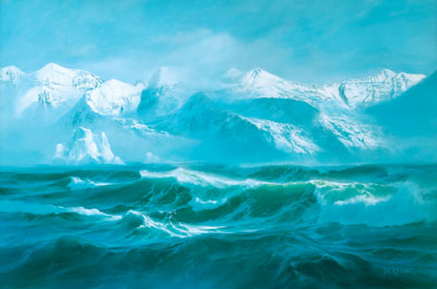
The upper Shuswap River would have raging creeks and waterfalls draining a vast ice field, with a similar landscape as that of the Columbia Ice Fields today. Connecting rivers or streams to the Shuswap, like Bessette, Duteau or Monashee may have been torrents of water tumbling down jagged ravines carved out of steep rock cliffs at the edge of the great glacier as it still covers most of the peaks of the Monashee Mountains.
The Blue Springs Valley between Lumby and Cherryville may have been part of a deep lake, which joined a large inland sea to the west. Around the perimeter would be old volcanic vents like the Camels Hump which would eventually emerge as sharp rocky outcroppings or islands not far from the shore.
To the east would be the beginning of a plateau, which we know as the Greystoke, Aberdeen or the Okanagan Highlands that would gently meet the sea. The shoreline would reach for many miles to the south and to the east to the foot of the Monashee and the ice fields. On this plateau we would find sand dunes and loose stone surrounded by the remnants of more ancient lava domes.
Opening of a Land Corridor
Over a long period of time this thin edge of land may have expanded into a wider corridor that would slowly grow in a north south direction. The planet warming along with volcanic activity beneath the surface of the Earth may have accelerated the melting of the ice fields in what is now central British Columbia. On each side of the corridor would be a wall of ice, which would feed water into vast catchment areas that may have included rivers and lakes.
There may have been Earth tremors, quakes and volcanic vents steaming through the landscape. The corridor was often a treacherous environment as the climate warmed, ice breaking from the glacier could create ice dams, which would cause flooding and divert water channels. In places this corridor would have remained narrow and inconsistent until it reached large plateau areas of land, and may have also disappeared completely into the great sea.
These large seas or glacial lakes may have been in existence for thousands of years allowing ecosystems to develop and flourish around them eventually reaching into the land corridors.
Ancient Habitat
The climate 15,000 years ago was beginning to warm and began to create a lush environment for plant life to thrive. Such an environment would have stayed relatively consistent for nearly 10,000 years as the last great ice age slowly subsided.
We can only speculate of the habitat that makes up this corridor of land. Melting glaciers were causing the climate to become moister but there would still be chilly winds and cold fronts coming off of the glacier areas. But the climate was cool and mild with significant rainfall, which caused some forms of vegetation to thrive.
Such a corridor may have consisted of a mix of woodlands and grasslands with most of the land being soggy. Pine, spruce and tamarack might makeup the forest that is carpeted with grass. There are grasslands with a vast number of ponds and bogs.
If one could imagine the upper reaches of the Monashee foothills and the Okanagan plateau areas as lush and park-like. There would be much less erosion present than today, and a much higher water table with marshlands and lakes covering what is now valley bottom areas.
Great Lakes and a Great Flood
During that time most historians have agreed that about 15,000 years ago there where at least three great lakes that formed in the western part of North America. These were huge catchment areas for great amounts of water caused by the melting of the massive glacier that was nearly equal in size to a polar ice cap.
Lake Missoula which covered what is now Montana; Lake Bonneville which covered parts of Nevada and Utah; and Lake Agassiz a vast lake covering much of Manitoba and western Ontario (almost the size of the Yukon) were three large lakes that would each be larger in size to any two of the Great Lakes of today.
According to many researchers the last ice age covered the entire area west of the Rockies, however there may be recent evidence that as the ice sheets melted, certain land corridors were exposed creating new lakes, possibly one in southern BC.
This fourth great glacial lake may have covered much of the south central interior of British Columbia including the Okanagan Valley. This great sea of water may have stretched from Wells Gray Park to the Canadian/US border.
While this lake still remains a theory, lessons can be learned from studying a similar ancient lake that was formed as a result of the last glacial advance that covered Montana and was moving south through the Purcell Trench in northern Idaho, near present day Lake Pend Oreille. A great ice dam on the Clark Fork River created Glacial Lake Missoula.
The water from the melting glacier began to build up behind the 900 meter high ice dam, which filled the valleys to the east with water, creating a glacial lake the size of Lake Erie and Lake Ontario combined. The water continued to rise until it reached its maximum height at an elevation of about 1500 meters. As the water rose, the pressure against the ice dam increased, ultimately, causing the dam to fail. The failure occurred when the water reached a depth of 700 meters. The water pressure caused the glacier to become buoyant, and water began to escape beneath the ice dam by carving sub-glacial tunnels at an exponential rate causing a catastrophic event of planetary proportions.
It is estimated that water moving at speeds of 120 kilometers per hour raced across eastern Washington at a volume 60 times the flow of the Amazon River, the largest river in the world today. At this rate, the lake probably drained in a few days to a week.
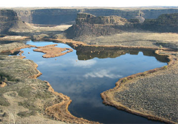
The floodwaters from Glacial Lake Missoula moved through eastern Washington on a 430-mile journey to the Pacific Ocean, forever changing the landscape by stripping away topsoil, and picking apart the bedrock. The floodwater carved an immense channel system across eastern Washington.
In 1928, geologist J. Harlen Bretz poetically described the scene: "No one with an eye for land forms can cross eastern Washington in daylight without encountering and being impressed by the 'scabland.' Like great scars marring the otherwise fair face of the plateau are these elongated tracts of bare, or nearly bare, black rock carved into mazes of buttes and canyons. Everyone on the plateau knows the “scabland”. It interrupts the wheat lands, parceling them out into hill tracts less than forty acres to more than forty square miles in extent. One can neither reach them nor depart from them without crossing some part of the ramifying scabland. Aside from affording a scanty pasturage, scabland is almost without value. The popular name is an expressive metaphor. The scablands are wounds only partially healed over the underlying rock which nature still protects."
British Columbia’s Great Inland Sea
The distinctive cliffs and terraces seen in the south Okanagan are one very obvious example of the landscape being formed by sand, silt and gravel deposition and shaped, to some extent, by melt water from the receding glacier. In fact the landscape was formed by very similar events that had carved out the scaplands of eastern Washington.
This was indeed an Earth alive and changing, but here too, something was about to happen about 15,000 years ago, perhaps in a single day, perhaps over a few hundred years. A series of quakes would shake at the north end of the great sea now called ancient Lake Penticton. The quakes were centred near what is now Wells Gray Park, causing a tectonic plate to shift and place extreme pressure on the entire catchment area that was already under pressure from increasing amounts of water draining into it from melting ice sheets.
The natural dam on the south end of the sea would burst causing the huge body of water to drain in one single cataclysmic event. This torrent of water would carve out the landscape much the same way Lake Missoula did. As the water dissipates a new landscape emerges, barren and muddy, but one that displays the characteristics more familiar to us today.
Legend
David Thompson:
Mammoth Hunter
According to Rolf Ludvigsen, Palaeontologist
Properly celebrated as Canada's mapmaker, David Thompson charted the entire western interior from Hudson Bay to the Pacific Ocean in 22 years of travels starting in 1789. He is, of course, closely associated with the Columbia Basin and the Kootenay region. In 1806 he established a trading post on Windermere Lake, and in 1811 he was the first European to travel the full length of the Columbia River from its origin at Canal Flats to Astoria near the mouth of the Columbia River.
Thompson could also claim a palaeontologic first because he launched the earliest systematic search for fossils in Canada. In 1797 when he quit the Hudson's Bay Company to become surveyor for the rival North West Company, he was given a short list of tasks to complete. In addition to items such as determining the precise location of company posts and promoting trade with the Mandan villages on the upper Missouri River, the partners of the company requested that, "in the interest of science and history he was to look for the fossils of large animals, and any monuments". No written record exists that explains the background or rationale of this remarkable directive. It might indeed have been for scientific purposes, but is it probably more likely that it alluded to mammoth ivory, which was already the object of lucrative trade in Siberia.
From his "Narrative of Exploration in Western North America", it is clear that Thompson took the directive to look for fossils seriously, but his searches along river banks across the prairies were all unsuccessful. However, mammoths were still on the mind of David Thompson and the Nor'Westers in 1811, when he led twelve men with eight dogsleds and four horses across the Athabasca Pass in the dead of winter to reach the Columbia River at the Big Bend on his way to the Pacific.
His men were startled to see a set of large tracks in the snow. Each footprint measured 14" long by 8" wide. Thompson thought that the track belonged to a large grizzly bear, but his hunters had a different idea: "Strange to say, here is a strong belief that the haunt of the Mammoth is about this defile, I questioned several, none could positively say they had seen him, but their belief I found firm and not to be shaken. They all agreed this animal was not carnivorous, but fed on moss and vegetables" (Nisbet, 1994).
David Thompson retired to Montreal in 1812 and never went west again. Mammoth bones and tusks were discovered in the 1840s, but in the Yukon and by an employee of the Hudson's Bay Company. Later George Dawson would make great pre-historic discoveries, and he too would leave his footprint in the Columbia and Monashee.
Source - Living Landscapes
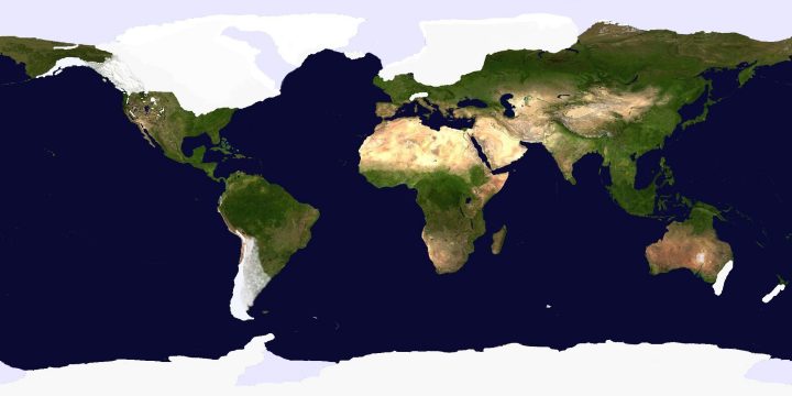
This image shows the Earth during the last ice age.
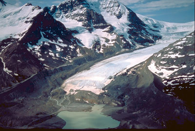
A photo of the Columbia Ice Fields in the Rockies. Eons ago as the glacier receded, mountain peaks would have appeared and the upper Shuswap River would have had raging creeks and waterfalls draining a vast ice field. The landscape in the Monashee may have been similar to that of the present day Columbia Ice Fields.
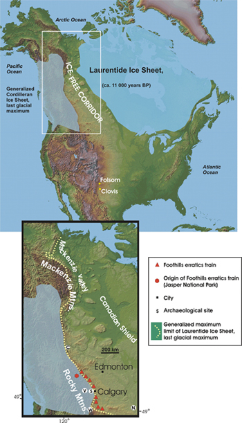
This map shows the extent of the Cordilleran and Laurentide Ice Sheets (LIS) at about 11,000 years before present, generalized from the deglaciation of North America. Between them is the main ice free corridor by which early animals traveled. The Cordilleran Ice Sheet covered nearly all of present day British Columbia but as the ice melted and subsided over thousands of years, ice free corridors began to emerge on the western side of the Rockies. These corridors would also become migration routes as plant life expanded through them.
An artist rendering of ancient Lake Missoula by Byron Pickering. The lake is connected to the landscape of the Okanagan as it played an important part of geological events 15,000 years ago.
The floodwaters from Glacial Lake Missoula moved through eastern Washington on a 430-mile journey to the Pacific Ocean, forever changing the landscape by stripping away topsoil, and picking apart the bedrock. The floodwater carved an immense channel system across eastern Washington now called the scablands.